Sunday, July 26, 2009

The Battle of Hill's Ironworks 1

The Battle of Hill's Ironworks
Part 1: Strategic Overview
Next: A Center of Resistance

By June, 1780, the British had mostly secured the state of South Carolina, and were looking forward to an invasion of neighboring North Carolina (for additional background information, see Occupied South Carolina, A Resistance Forms, and Seeds of Defeat). In June, the British were successful in expelling the American militia from South Carolina, but not before the American militia gained morale-boosting victories over their Loyalist counterparts. Meanwhile, in North Carolina, hundreds of Loyalists began to organize in anticipation of a British invasion, but these were scattered by the American militia of that state. The map below and the accompanying text provides additional details about the situation.

Numbers in red refer to British-occupied locales on the map. British forces were scattered across a network of posts in the Backcountry. One of the most important posts Among the principle British posts in the South Carolina Backcountry were Camden (1), Ninety-Six (2), Rocky Mount (3), and Hanging Rock (4). On or about June 6, American militia under John McClure routed a party of Loyalists at Alexander's Old Field (located within the red circle surrounding Rocky Mount), and on June 8, Americans commanded by Richard Winn, William Bratton, and John McClure performed a similar feat over Loyalists at Mobley's Meeting House (5). In North Carolina, hundreds of Loyalists organized at Ramsour's Mill, where they were defeated on June 20, in the most important battle of the month.

Numbers in blue refer to American occupied locales on the map. Significant American resistance coalesced in North Carolina, with the town of Salisbury (1), serving as one of the main focal points. In mid-June, numbers of South Carolinians organized in North Carolina at Tuckasegee Ford (2), and elect Thomas Sumter as their leader. One previous center of resistance was William Hill's Ironworks (3), which was destroyed by Christian Huck's mixed force of Provincials and Loyalist militia, detached from Rocky Mount. Another setback for the Americans occurred on or about June 10, when Thomas Brandon's South Carolinians (4) were defeated by William Cunningham's Loyalists, based in Ninety-Six.

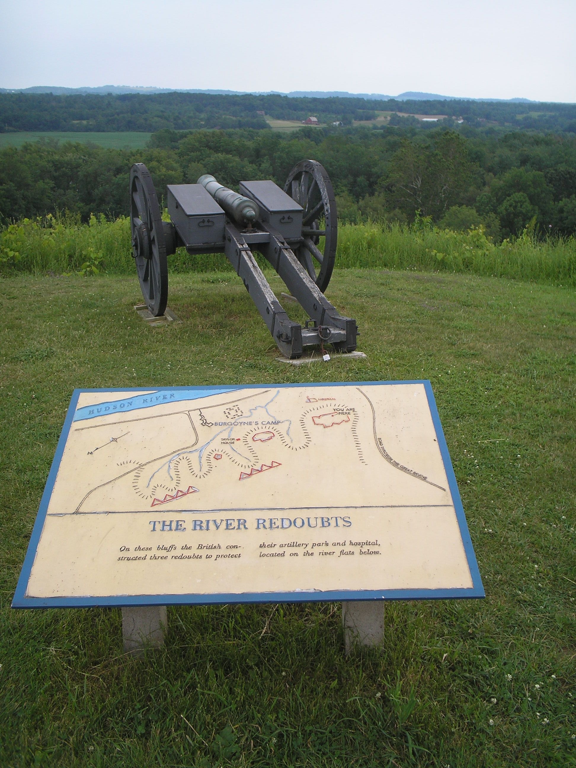
Contested Carolina, June 6-20, 1780 (click to enlarge). The dark line bisecting the map is a part of the boundary between North and South Carolina. Map section from Henry Mouzon et al.'s 1775 An accurate map of North and South Carolina...

Sources:

Michael C. Scoggins. (2005). The Day It Rained Militia: Huck's Defeat and the Revolution in the South Carolina Backcountry, May-July 1780. (link to amazon.com).

John A. Robertson et al.'s Global Gazetteer of the American Revolution.

Tuesday, July 21, 2009

Seeds of Defeat

[Revised for concision, May 2, 2010]

On June 4, 1780, British Lieutenant-General Henry Clinton wrote to George Germain, Secretary of State for the Colonies, to describe the situation in South Carolina. Clinton had turned over command in the South to Lieutenant-General Charles Cornwallis, and was preparing to return to the main British base of operations at New York. Clinton cheerfully reported that:

"With the greatest pleasure I further report to your lordship that the inhabitants from every quarter repair to the detachments of the army and to this garrison to declare their allegiance to the King and to offer their services in arms in support of his government. In many instances they have brought prisoners their former oppressors or leaders, and I may venture to assert that there are few men in South Carolina who are not either our prisoners or in arms with us."

Clinton was not alone in this opinion. Others writing to Germain at this time expressed a similar view.

On June 9, Loyalist James Simpson wrote to say that:

“the gentlemen in the country seem unanimously inclined to a restoration of the King’s government, whereas in town [Charleston] there are still some who associate in small parties and stimulate each other to continue in the rebellious principles which they have nurtured for some time past, and there is no doubt but that if they dared it would break out into practice; but they are very few, and I trust nothing that can happen will prevent the establishment of His Majesty’s authority and government which I am confident is eagerly wish for by four-fifths of the people.”

On June 10, the Crown-appointed (and exiled) Governor of North Carolina, Josiah Martin, wrote that:

“I have the great satisfaction to acquaint your lordship that this province is in all appearance subsiding fast into a state of peace and tranquility under the auspices of Lord Cornwallis whose wise and prudent measures I think cannot fail to confirm and secure it ours if they are not contravened. His lordship is pursuing the only plan of justice and policy that I have yet known conjoined with military operation in the course of the American war, and if the future measures of government relative to this people are founded upon the same just and sound principles of determination I think I may venture to affirm that Britain will again hold empire here."

As described previously, American accounts also indicate that submission to the Crown was widespread. Nevertheless, at the very moment when the British appeared on the verge of complete triumph, the seeds were being sown for their eventual defeat in the South. I will not attempt an exhaustive account of how British decisions at this period contributed to their defeat, but some likely contributing factors are listed below.

1. The British were slow to effect the reestablishment of Royal authority in South Carolina. Simpson complained to Germain that:

“I am to remain here for some time in order to contribute my assistance to establish and carry into execution a temporary civil police for the government of the country which must otherwise fall into anarchy and confusion, even if no persons were to remain in the province who are so infected with rebellious principles… I must consider it a misfortune that at a time when so much assistance is wanted there is not one of the King’s servants belonging to this province upon the spot except myself, and even my stay is precarious…”

2. Although the British demanded the allegiance of South Carolinians, they did very little to earn it. Many of the people that expressed support for the Crown did so out of precaution and not because of a change of heart. From a 21st-Century vantage point, one can argue that a hearts-and-minds campaign should have been launched, that high-ranking officers should have been sent into the Backcountry settlements to talk to the leaders about their fears and grievances and attempt some kind of accommodation. In any event, this did not occur.

3. British efforts to subdue the state were not uniform. Clinton's inclination was to be lenient with the people of South Carolina: his June 3 proclamation released the militia that had borne arms against him from their paroles so long as they supported the Crown. This proclamation struck some British officials as ill-considered, and they felt free to go their own way. Martin warned that:

“if… in the spirit of concession and indulgence, innocence and guilt are confounded by undistinguished favour and lenity, and the means are unemployed which only have been found effectual to cure rebellion in all ages and countries, your lordship may depend the result will be nothing better than an unsound pacification, a shortlived truce to be soon followed by hostility more combined, compacted and confirmed.”

In other words, Martin was concerned with incentives; he wanted to ensure that those that were loyal to the Crown would be recognized and rewarded, whereas those that had not would be effectively dissuaded from rebellion.

Others favored the ruthless application of force to terrorize the population into submission (most notorious were Captains William Cunningham and Christian Huck).

Whatever benefit there was in any one of these strategies was undermined by the concurrent use of other strategies.

4. The British military response to unrest was inadequate. Previously, I suggested that Cornwallis' plan to establish a network of (chiefly) Provincial-manned outposts in support of a new, Loyalist militia could have been central to a winning British strategy in the South. The British had few men relative to the territory they had to control. It was necessary for them to either spread themselves thin in an effort to control the countryside, or cede it, without a fight, to the Americans.

Once the American militia in the Backcountry became active and showed that it could dominate fights against their Loyalist counterparts [see Note 1], it was incumbent on the British to develop an effective response. However, the British were hampered by difficulties. The British might have embedded experienced officers in the ranks of the Loyalist militia, but they had few spare officers. Alternatively, the British might have developed a powerful, mobile reserve that could be sent to hot spots, but they had a shortage of horses and forage.

Notes:

1. It is unclear whether the Loyalists or Whigs could count more supporters in June of 1780. Perhaps more important than an advantage in numbers was the Americans' advantage in military experience. In a painstaking analysis of the battle of Williamson's Plantation, Michael C. Scoggins identified 142 participants on the "American" side. Of these, at least 33 (23%) had prior service as Continentals in either the 3rd or 6th South Carolina regiments. The defeat of Loyalists in early June at Alexander’s Old Field and Mobley's Meeting House presaged a future in which the American militia would frequently dominate their Loyalist counterparts.

Sources:

Transcriptions of letters by Clinton, Simpson, and Martin in K. G. Davies. (1978). Documents of the American Revolution 1770-1783 (Colonial Office Series). Volume XVIII: Transcripts 1780. Irish University Press.

The website, The Colonial and State Records of North Carolina, hosted by the University of North Carolina, includes a transcription of the Letter from Josiah Martin to George Germain, June 10, 1780.

Michael C. Scoggins. (2005). The Day It Rained Militia: Huck's Defeat and the Revolution in the South Carolina Backcountry, May-July 1780. (link to amazon.com).

Saturday, July 18, 2009

Sumter Project

The British overran the state of South Carolina in May, 1780, and attempted to restore it as a British colony. Important actions were fought during this time in the South Carolina Backcountry that helped keep this from happening. For this project, emphasis is placed on battles involving the brigade of American militia commanded by Thomas Sumter in July and August of 1780.

-------------------------------------------------------------------------------


Background Information (Wikipedia Links)

-------------------------------------------------------------------------------

Recommended Reading

John Buchanan. (1997). The Road to Guilford Courthouse: The American Revolution in the Carolinas.

Michael C. Scoggins. (2005). The Day It Rained Militia: Huck's Defeat and the Revolution in the South Carolina Backcountry, May-July 1780.

-------------------------------------------------------------------------------

Blog Posts

May-June, 1780:

Occupied South Carolina

A Resistance Forms

Seeds of Defeat

The Battle of Hill's Ironworks (1) (2) (3)

Sumter's Brigade Forms

-------------------------------------------------------------------------------

July, 1780:

The Battle of Williamson's Plantation (1) (2) (3) (4) (5)

The Battle of Rocky Mount (1) (2) (3) (4)

-------------------------------------------------------------------------------

August, 1780:

The Battle of Hanging Rock (1) (2) (3) (4) (5) (6) (7) (8) (9) (10) (11) (12) (13)

The Battle of Fishing Creek (1) (2) (3) (4) (5)

Sumter’s Brigade Reforms

-------------------------------------------------------------------------------

Some American Military Units Involved:

Some British Military Units Involved:

Thursday, July 16, 2009

Touring the Revolution with the Historical Marker Database

In a previous post, I described how it is possible to "see" sites associated with the American Revolution using Google Earth. In this post I'd like to make mention of another outstanding website: the Historical Marker Database. In brief, this is an online compendium of historical markers, well illustrated by contributors' photos. As an example of what this website has to offer, I've compiled below a list of markers associated with the Battles of Saratoga: Freeman's Farm (September 19, 1777) and Bemis Heights (October 7, 1777). I've also embedded a few images to provide a sense of what's available online (which you can click to enlarge), but you're encouraged to also click on the links to see the web page for each marker. Each web page provides multiple views, so you can not only see the marker in detail, but also its surroundings. The web page for each marker also includes the exact geographic coordinates of each marker, and a link to Google Maps, so you can see exactly where the marker is located, and a satellite view of the area.

Freeman's Farm (September 19, 1777)

North Redan

American River Defense


American River Fortifications

Patriots’ Eye-View

Anchor of the American Line

Redoubt


Earthworks

Kosciuszko

Thaddeus Kosciusko

John Neilson House and Farm

American Encampment and General Headquarters


Main British Encampment

Burgoyne’s Headquarters

Strategy and Terrain

Freeman House

Prelude to History

The Battle of Freeman’s Farm


New Hampshire Memorial

Zebulon Bidwell


Bemis Heights (October 7, 1777)

Bemis Heights

The Great Redoubt

The River Redoubts


Asa Chatfield Farm

Site of Chatfield Farm


The British Advance on Bemis Heights

The Battle Begins at Barber’s Wheat Field

Saratoga 1777

Saratoga 1777

Brig. Gen. Abraham Ten Broeck

Colonel Joseph Cilly

Brigadier General Simon Fraser

General Fraser Was Struck


Here Frazer Fell

Saratoga 1777

The British Withdraw

Americans Attack

Bloody Knoll

The Balcarres Redoubt

Crown Forces


The Breymann Redoubt

Arnold’s Assault

Benedict Arnold Boot Monument

Burgoyne’s Retreat


Burial Site of General Fraser

Unknown American Soldiers

Unknown Soldiers

Saturday, July 11, 2009

A Resistance Forms

[Minor revisions May 2, 2010]

By the end of May, 1780, the Continentals had been eliminated as a fighting force in South Carolina. Much of the state militia had been captured at the siege of Charleston and subsequently paroled. Other American partisans (or more precisely, armed Whigs) had been captured by the Loyalist militia.

The Loyalists of South Carolina began to declare themselves openly for Great Britain. Some, having been previously persecuted, sought to revenge themselves.

Joseph Gaston recalled with bitterness that "Bandilla of Traitors & Robers which English Policy decorated by the names of Loyalists began their work and privations on the defenseless Whigs." In his neighborhood, a "young man Captain John McClure... collected 32 Volunteers (whose Motto was Liberty or Death)." On or about June 6, 1780 they fought back and "attacked and Scattered the camps of the Loyalists under the Command of Colonel Houseman... at the place now known by the name of Beckhamsville" [see Note 1]. On account of this success, "This Spartan Band soon increased."

On June 3, 1780, British Lieutenant-General Henry Clinton issued a proclamation to the citizens of South Carolina, which read in part that "all the inhabitants of this province, who are now prisoners upon parole... are freed [as of June 20] and exempted from all such paroles, and may hold themselves as restored to all the rights and duties belonging to citizens and inhabitants." No doubt, this was intended to be a magnanimous gesture. In return, Clinton demanded that "all persons under the description before mentioned [i.e., the parolees], who shall afterwards neglect to return to their allegiance, and to His Majesty's government, will be considered as enemies and rebels to the same, and treated accordingly." In other words, it was not enough to grudgingly resign oneself to the British occupation, to remain at home and hope for a change in fortunes. Instead, anyone that did not actively support the British would be considered an enemy.

South Carolinian James Collins remembered that the British sent officers "out in various directions, with guards or companies of men, to receive the submission of the people. Vast numbers flocked in and submitted; some through fear, some through willingness, and others, perhaps, through a hope that all things would settle down and war cease." However, some Americans were alarmed by this proclamation. In Collins' words, "the patriots of the day could not submit to [these terms] and therefore determined to hold out a little longer."

These stalwarts described in pension applications and postwar memoirs, the beginning of wide-scale organized resistance to the British. This resistance began with determined individuals and small bands of like-minded men fleeing to the comparative safety of North Carolina.

To provide a few examples:

Samuel Gordon recalled, "The whole country was at this time so over run with the enemy it was impossible to return home, myself & 26 others... were under the command of Colonel Neel." They sought to join "the Army of the Whigs wherever we could find them."

Henry Rea "with nine other Whigs after the fall of Charleston rather than take British protection, fled, with Captain Jamison at their head to North Carolina."

John Weldon remembered being told "by a Tory Sergeant that... he must deliver himself up or join the Enemy... which rather than do he broke his parole collected a few of the men of his company took the command of them."

In the days and weeks that followed, these groups coalesced into a small army of militia on the edge of the chain of British outposts.

Notes:

1. This is known as either the battle of Beckhamville or Alexander's Old Field; the latter was the name of the site at the time of the battle. For more on this engagement, see Michael C. Scoggins' history of the battle, Alexander's Old Field, or the Battle of Beckhamville, which appears in this issue (.pdf file) of Southern Campaigns of the American Revolution.

Sources:

Will Graves transcribed the pension application of Joseph Gaston (.pdf file).

A complete transcription of Clinton's proclamation appears in William Moultrie's 1802 Memoirs of the American Revolution.

James Collins' 1859 Autobiography of a Revolutionary Soldier.

Will Graves transcribed the pension application of Samuel Gordon (.pdf file).

Will Graves transcribed the pension application of Henry Rea (.pdf file).

C. Leon Harris transcribed the pension application of John Weldon (.pdf file).

Monday, July 6, 2009

Touring the Revolution with Google Earth

I never ceased to be amazed at how many Revolution-related resources are on the Internet. As I don't live near the battlefields of the Revolution, I've enjoyed using Google Earth to "tour" sites not readily accessible to me. Below I describe a couple of basic features of this software, illustrated with screenshots (in all cases you can click to enlarge).

First, finding sites of historical interest is generally quite easy. Use the Search feature to find the place that you're looking for. Below I searched for "Fort Stanwix" and the program instantly transported me to the reconstructed Fort Stanwix in Rome, New York. I then zoomed in somewhat to obtain the view below.

I turn off most of the options in the Layers menu, but one that I keep on are the links to Panoramio pictures in the Geographic Web menu. These are user-submitted images that provide a ground-level view of the area. More often than not, the images are frankly beautiful as in the picture below of the Old North Bridge at Concord. On the right side of the image you can see the controls for zooming, panning, and rotating the image.

Unfortunately, many battlefields of the Revolution have not been well preserved. Two of the better exceptions among northern battles are Freeman's Farm/Bemis Heights and Monmouth. At present, there are only a handful of Panoramio pictures for these battlefields, but that is sure to change over time. A great user-submitted image of Monmouth appears below.

Some of the best places to see -- both in person and online -- are the sites of 18th-Century forts. Below is one of several images of handsome Fort Chambly in Canada, the site of an obscure, but historically important, action early in the war.

Yorktown, Virginia, is particularly worth visiting with Google Earth, as the extant fortifications are easily visible from the air, and the many visitors to the battlefield have generated some fantastic images, such as that of the recreated 1st Virginia Regiment, taken near the site of Redoubt #9.

One other feature worth exploring is the "Street View" option (in the Layers menu). By entering Street View, you can have a 360-degree view of a particular spot on a roadway. Barring the slight fuzziness of the images, this is almost as good as being there. Generally, only major roads have been imaged this way, which limits the usefulness of this feature, but for some battlefields this is useful. The screenshot below shows a Street View image taken on Flat Rock Road, revealing a portion of the Hanging Rock battlefield. Each camera icon is the location of another available view. Although not clear from this image, one can travel for miles along this road using Street View.

Yorktown is the rare locale where the normal aerial view, the links to Panoramio pictures, and the Street View option all can be used to study the battlefield. Below is an aerial view of the "Hornwork," a key position in the British defenses that was heavily pounded by the French and American artillery. The cars in the foreground provide a good sense of the enormity of this work.

Below is a Street Level view of the Hornwork, taken from the road visible in the image above.

Saturday, July 4, 2009

Occupied South Carolina

[Minor revisions May 2, 2010]

On May 12, 1780, the American army in the Southern states, commanded by Major-General Benjamin Lincoln, surrendered at Charleston to a British army commanded by Lieutenant-General Henry Clinton. It was the worst American defeat of the war. Subsequently, Clinton left Lieutenant-General Charles Cornwallis with command in the South.

The British soon established a network of outposts across South Carolina. On the Atlantic coast, posts were established at Georgetown and Beaufort. The main base of operations was at Charleston. In the central part of the state, a post was set up at Camden. To defend the border with North Carolina, posts were established at Rocky Mount, Hanging Rock, and Cheraws. In the west, posts were established at at Ninety-Six, "Sennica Fort," and Fair Forest.

A Section of Henry Mouzon et al.'s 1775 An accurate map of North and South Carolina... (click to enlarge). 1 is "Sennica Fort," 2 is Fair Forest, 3 is Ninety-Six, 4 is Rocky Mount, 5 is Hanging Rock, 6 is Camden, and 7 is Cheraws.

Clinton left Cornwallis with six regiments of British infantry (the 7th, 23rd, 33rd, 63rd, and 64th regiments of foot), and two regiments of German infantry (Fusilier Regiment Ditfurth and Garrison Regiment von Huyn). Cornwallis generally did not place his regulars in the more vulnerable posts (although there are exceptions: the 23rd was at Hanging Rock for a short while in early July and the 71st was at Cheraws for a longer period). Rather, the northern and western posts were manned chiefly by regiments of provincials. For example, the 3rd battalion of New Jersey Volunteers, the 1st battalion of DeLancey's brigade, and the South Carolina Royalists were assigned to Ninety-Six, the American Volunteers were at Fair Forest, and the New York Volunteers were at Rocky Mount.

Cornwallis was concerned with establishing a Loyalist militia in the state, and 18 regiments were organized. The outposts were important to the formation of these militia regiments, because they provided places where Loyalists could gather in safety, and receive arms and instructions. The placement of provincials in these outposts was perhaps deliberate. The provincials, of course, were diehard Loyalists, and it may have been thought that their presence would have a good effect on the civilian population.

A South Carolina Loyalist militia backed up by provincial regiments would seem like an effective strategy for completing the subjugation of the state. The former were well acquainted with the countryside and knew the "rebel" leaders. The latter were well armed veterans. It's not unreasonable to believe that the Loyalists should have been able to track down the bands of American militia, even infiltrate their organizations, and, with the help of the provincials, wipe out the remaining resistance.

If Cornwallis' strategy was effective in South Carolina, it reasonably might have worked in some other parts of the United States (North Carolina most obviously being the next target). Therefore, events in the South Carolina backcountry in the summer of 1780 would provide a critical test of Britain's ability to win the war.

Sources:

Letter from Brigadier-General Thomas Sumter to Major-General Johann de Kalb, July 17, 1780.

John A. Robertson et al.'s Global Gazetteer of the American Revolution.

William T. Sherman. (2009). Calendar and Record of the Revolutionary War in the South: 1780-1781. (pdf file).

Michael C. Scoggins. (2005). The Day It Rained Militia: Huck's Defeat and the Revolution in the South Carolina Backcountry, May-July 1780. (link to amazon.com).

Rodney Atwood. (2002). The Hessians. (link to amazon.com).

The On-Line Institute for Advanced Loyalist Studies. A History of the 3rd Battalion, New Jersey Volunteers.

The On-Line Institute for Advanced Loyalist Studies. A History of the 1st Battalion, DeLancey's Brigade

The On-Line Institute for Advanced Loyalist Studies. New York Volunteers Officers' Memorial.