Friday, January 29, 2010

The Hanging Rock Battlefield in Miniature

Recently, I described how I was working on a version of the Hanging Rock battlefield, at a 1:20 scale for 15mm miniatures. That battlefield is now more-or-less complete and is shown below.

I first had to identify the area in which the fighting was likely to have taken place (see here, here, and here). Early on I realized that I couldn't make an exact representation of the area as it likely appeared in 1780. Therefore, I settled on a certain amount of abstraction. I didn't create miniature hills, ravines, and watercourses per se, but rather represented these things using variations in the "vegetation." Also, the trees are spaced somewhat far apart; this is necessary so that I can move the miniatures about on the battlefield. As a consequence of these decisions, the miniature battlefield may not closely resemble the Hanging Rock Creek area in 1780, but it at least captures something of the flavor of the time and place.

Two Maps of the Hanging Rock Battlefield (click to enlarge). The map on the left is from Google Maps. The map on the right is from ACME Mapper. In both cases, today's Flat Rock Road (which follows roughly the same path as the 18th-Century Camden Road) runs from north (at top) to south. Hanging Rock Creek runs from the top of the map to the right. I believe Bryan's North Carolinians were encamped on the hill near the upper right. The lakes in the area were not present in the 18th Century. Several small streams in the area are not represented on the map on the left.

Hanging Rock Battlefield in Miniature (click to enlarge). As per above, the Camden road runs from north to south. The farmland at center left is the site of the center camp (note the brush hut near the cabin). The encampment of Bryan's North Carolina Volunteers is in the woods at the upper right. The encampment of the Prince of Wales' American Regiment is in "Cole's Old Fields" near the lower right.

Monday, January 25, 2010

Further Thoughts on Rocky Mount

I recently finished my research on Hanging Rock. In so doing, I came across some additional information on the battle of Rocky Mount that I missed before. The most important information concerns British losses. Lieutenant-General Charles Cornwallis wrote to Lieutenant-General Henry Clinton on August 6, 1780 that “We had on our part an Officer Killed & one wounded, & about ten or twelve men killed & wounded” [1]. Interestingly, the official return of losses submitted by Cornwallis to George Germain on August 20, 1780 lists 8 killed, 31 wounded [2]. I only have access to a summary, not the return itself, so I cannot shed any light on the cause of the discrepancy (e.g., does one total cover only the Provincial forces involved and the other both Provincials and militia?). Neither statement mentions missing, which might be expected given claims by the Americans that some prisoners were taken. The total of 39 killed and wounded is surprisingly high, suggesting British losses of around 13%, and possibly higher. This seems like an unlikely loss rate if the Americans were inflicting casualties only by shooting into the portholes of the British-occupied log houses. (By comparison, American losses, if reported accurately, did not exceed 4%).

There are two plausible ways that such high losses could have been inflicted.

First, some of the defenders may have been struck down while out in the open. As described in that series, a party of British Legion dragoons was caught out in the open at the beginning of the battle. As also noted, some of the Loyalist militia were stationed in a redoubt, but were soon driven into the works. Here is another pension application that supports the latter claim:

William McGarity claimed, “we marched against Col[onel] Turnbull at Rocky Mount and drove them from their works into a house from whence we could not dislodged them” [3]. None of the accounts I’ve read indicates that the Loyalists lost men while fleeing the redoubt, but it’s certainly plausible, especially if they were not near the gate, or if the abatis was difficult to cross.

Second, American Lieutenant-Colonel William Hill claimed that the British were in a frame house and that he expected that the Americans’ bullets would easily penetrate the wood, striking down the defenders inside. I pooh-poohed this description because Hill is not the most reliable source, and other sources agreed that the British were in log houses [see Note 4 in this post]. However, I recently came across a would-be pensioner that agreed with Hill. James McConnel claimed that, “the force of the British & Tories he does not know, these were in a large frame house stockaded round from which the Americans tried to drive them but without success as they were unprovided with cannon" [4].

So possibly one of the buildings that housed defenders was a frame house, and the defenders inside were quite vulnerable to the Americans’ gunfire. Hill claimed that while the frame house appeared to be vulnerable, the British "had placed small logs about a foot from the inside of the wall and rammed the cavity with clay" [5]. But how could he know? The Americans didn’t have an opportunity to inspect the site until almost 2 weeks later (after the British abandoned the post), and this may reflect an improvement that was made after the battle. The gun shot holes from the battle would have remained in the exterior of the building, leading Hill to a false conclusion.

Notes:

1. Letter from Charles Cornwallis to Henry Clinton, August 6, 1780.

2. Enclosure in a letter dated August 20, 1780 from Charles Cornwallis to George Germain. In K. G. Davies (Ed.), Documents of the American Revolution 1770-1783 (Colonial Office Series), Vol. XVI. Irish University Press.

3. Pension application of William McGarity, transcribed by Will Graves.

4. Pension application of James McConnel, transcribed by Will Graves.

5. William Hill's memoir, transcribed by Will Graves.

Friday, January 22, 2010

British Legion Redux

When I first decided, last summer, to spend a lot of time with the battle of Hanging Rock, I thought that I would be able to use many of the same miniatures I had painted for my Cowpens project. Gradually, however, I’ve been moving away from that decision and I’ve painted up a number of minis that will be of specific value to this battle. The latest batch I’ve been working on are British Legion Infantry. The first 15mm-high British infantry I painted (some years ago) was a group representing the 64th Foot; I used these for the Legion infantry at Cowpens for reasons briefly articulated here.

In researching Hanging Rock, it's become clear to me that the Legion infantry were dressed in green jackets similar to those worn by the Legion dragoons. A party of mounted Legion infantry arrived at Hanging Rock near the close of the battle (Lieutenant-Colonel Banastre Tarleton described them as “Captains Stewart and M'Donald, of the British legion… with forty mounted infantry.” However, American sources mistook them for the dragoons (e.g., William Davie claimed that “some of the legion cavalry appeared”).

To create green-jacketed Legion infantry, I selected some Minifigs British light infantry figures that I had primed some time ago but not painted. The figures were painted using Vallejo Game Colors. I don't have a large selection, so I routinely mix my paints. The jackets, for example, are the result of mixing Sick Green, Beastly Brown, and Stonewall Gray. The figures were primed with white, but I first painted all the metal parts black. Faces were painted with Pale Flesh and then given a brown wash. I drybrushed the caps and feathers with white.

The mostly-completed figures appear below. I still have to varnish the figures and flock the bases.

Wednesday, January 20, 2010

The Hanging Rock Battlefield - Part 5

Final Thoughts

The site I proposed for the British camps at Hanging Rock is a good match with participant accounts and military exigency -- more so, I believe, than other locales linked to the battle (cf. here and here). However, a caveat is in order. I have not hunted down every scrap of information on the battle of Hanging Rock. There are at least two important omissions of which I'm aware. One is that I have not read the so-called Sumter Papers [see Note 1], with the exception of an account by Joseph McJunkin that has been reproduced elsewhere. From what I know of the Sumter Papers, the accounts are primarily a good place to learn of memorable incidents involving particular individuals. (This has also been my experience reading transcribed pension applications). It would be good to know whether such accounts support the views I've adopted, but because the accounts I have read and will be using are especially likely to be trustworthy, I'm not sure that I would allow statements in the Sumter papers to "overrule" them if they offer a contradictory recollection.

The other concerns the activities of relic hunters in the area. I'm aware that artifacts that seem to date to the 18th Century (see here) have been found on or near the Battlefield Property. Do such findings prove that my description of the battlefield is incorrect? I don't believe so.

First, the area was not only the site of a military encampment in the summer of 1780, it was also used on a number of other occasions (including as recently as the Civil War) as a military encampment. The defensive alignment necessary in the summer of 1780 was not required on the other instances. Thus, some of the those other encampments could well have been nearer the Hanging Rock.

Second, the Hanging Rock was a well-known curiosity, and soldiers in the area would have visited it even when they were encamped elsewhere [see Note 2]. Likewise, civilians passing through the area (like Benjamin Lossing) were drawn to this spot. Because the rock formation lies on the far side of a ravine, it's not difficult to imagine that various persons would have left small items behind as they negotiated the difficult terrain.

Third, natural processes and human activity have removed from the environment most of the debris from Revolutionary War battles. While there are still relics to be found, what is left may not provide a clear picture of past events. This problem is well illustrated by a recent survey of the Eutaw Springs battlefield [see Note 3].

Notes:

1. These are not Thomas Sumter's papers, but rather interviews with some of Sumter's men and other historians' notes gathered many years later.

2. Benjamin Lossing heard that some Provincials slept under the Hanging Rock the night before the battle; in my account, the closest troops were those of the Prince of Wales' American Regiment. Particularly striking is the account North Carolina militiaman Guilford Dudley gave of his retreat from the battle of Camden. As he rode north, along the Camden Road, he "at last gained the spot which I deemed to be in the immediate vicinity of the Hanging Rock." Although fleeing Tarleton's dragoons, he began "casting my eye on the right and left and in front, to see if I could discover the noted mass, called the 'Hanging Rock,' of which I had heard so much." (Unfortunately for Dudley, the rock formation could not be seen from the Camden Road).

3. Described in this issue (.pdf) of Southern Campaigns of the American Revolution (see page 35).

Monday, January 18, 2010

Images of the Hanging Rock Battlefield

Previously, I made the case that the battle of Hanging Rock was fought on a height south of where present-day Flat Rock Road crosses Hanging Rock Creek, and on a neighboring hill. A map that I presented in that post appears below. The red circles show the locations of the three British camps. The circle nearest the upper right represents the encampment of Samuel Bryan's North Carolina Volunteers, the circle below and to the left of this point represents the encampment of the British Legion infantry and the Royal North Carolina Regiment (this is also known as the center camp), and the circle nearest the bottom represents the encampment of the Prince of Wales' American Regiment (PoWAR). These British forces guarded the Camden Road (the brown line; this followed approximately the same path as today's Flat Rock Road).

Topographic maps provide an imperfect sense of place; it helps that one can take a virtual tour of Revolutionary War battlefields using Google Earth. Below are several screen shots I made of the approximate site of the center camp and the PoWAR camp, as seen from Flat Rock Road.

The Flat Rock Road, near the site of the center camp. The view is northwest; the crest of the elevation is to the right. Near the trees in the middle ground, the road slopes steeply downwards and turns towards the north. The British post at Hanging Rock was designed to prevent the Americans from coming down this road (i.e., towards the viewer).

The same location, but looking in the opposite direction (i.e., southeast). The area near Hanging Rock is hilly and cut by numerous ravines. This relatively flat plateau was attractive to early settlers.

The same location, looking northeast. The crest of the height is at the right edge of the image, a short distance behind the trees. The profile of the slope can be made out in the distance. William Davie claimed that "the regular troops [actually, Provincials] could not be approached without an entire exposure of the assailants." The slope is gentle enough that this land may well have been cleared by settlers prior to the battle. A nearby stream would have helped make this site attractive. If this interpretation is correct, one can understand Davie's apprehension: The direct approach to Hanging Rock would have led the American troops to advance up this slope from the left towards the British infantry and two 3-pounder guns on the right. To circumvent this danger, the Americans chose to attack the center camp on its flank.

Much of the area around Hanging Rock is woodland today, just as it was in 1780. Today the area is covered by second-growth forest, but the mix of deciduous and coniferous trees one finds in the area today is probably not unlike the original forest.

This image (looking east) was taken near the site of the PoWAR's camp (the lower red circle). The Flat Rock Road is in the foreground; the road heading into the background passes near the Hanging Rock. The distant trees are on the Hanging Rock Battlefield Property. The historical marker at right is for the James Ingram house. To read the marker, click here; the site of the John Ingram house can be seen on Mills' 1825 map of Kershaw District; note the proximity to the marked site of the battle of Hanging Rock.

Saturday, January 16, 2010

The Hanging Rock Battlefield - Part 4

An Alternative Proposal

In the previous two posts, I considered two different points of view about the location of British forces at the battle of Hanging Rock in South Carolina (see here and here). To evaluate these accounts, I developed an "objective" rating system that compared how well the landscape identified by these accounts matches that appearing in descriptions of the battlefield. Noteworthy, is that neither account rated better than a 75% under this system, suggesting that there is room for improvement. I therefore set about examining the terrain features in this area carefully, in order to determine whether there is some constellation of terrain features that would match participants at a higher rate.

A scheme that is a good match for participant accounts is shown in the map below. A description follows.

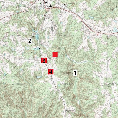
The center camp is located on top of a hill overlooking Hanging Rock Creek, at the approximate spot identified as the Hanging Rock battlefield on Mills' 1825 map of Kershaw District, South Carolina. (#3 on the map).

The right camp is located on top of a nearby high that is bounded by Hanging Rock Creek on two sides, a short distance upstream from the eponymous rock formation (the rock formation is #1 on the map).

The left camp is located on the Camden Road, at the approximate site of Cole's Old Fields. (#4 on the map).

Objective Assessment

1) The three camps were on elevations. 2 points.

2) Colonel Samuel Bryan and his North Carolina volunteers were encamped on the right of the British position. 2 points.

3) Bryan's men were encamped on a steeply-sloped hill bordering a creek. 2 points.

4) Bryan's men were encamped south and west of Hanging Rock Creek, near the "Hanging Rock." 2 points.

5) The hill on which Bryan was encamped curved in one place at nearly a 90-degree angle. 2 points. Remarkably, the hill has exactly this feature, as shown in the topographic map below. To highlight the hill shape, I've marked two of the contour lines in bold. Also important that this bend in the hill is pointed towards a defile (on which a blue arrow is placed) through which I believe the Americans advanced (see section below concerning William Davie's account of the American advance).

The red circles on this map are the three camps. The green box is described below.

6) To the left of Bryan's position there was a swampy patch of ground. 1 point. There is a flat patch of ground in the appropriate area in which several streams converge, but there is no "swamp" icon on this spot. This area is marked by the green box in the map above. The absence of a swamp icon may only be because the area is not large in extent.

7) Bryan's camp was about 1/4 to 1/2 mile from the center camp. 2 points. The distance is about .37 miles.

8) The Provincials were encamped, in part, on or near "Cole's Old Field." 2 points.

9) The Provincials were encamped on or near the Camden Road. 2 points. This is the brown line on the map above.

10) More than 1/4 mile separated the center camp from the left camp. 2 points.

Total Score: 19 points (95%).

Subjective Assessment

Aside from agreement with the 10-item list, there are several good reasons to adopt this interpretation of the placement of the British camps at Hanging Rock. These include 1) agreement with William Davie's description of the American route of attack, 2) agreement with participant descriptions of a British flank attack during the battle, and 3) the relative military soundness of this alignment.

1) William Davie on the American Advance. William Davie described the difficulties the Americans faced in attacking the British post as follows:

"the situation of the regular troops could not be approached without an entire exposure of the assailants, and a deep ravine and creek covered the whole point of the Tory camp."

In the account that I've described, this makes perfect sense. The center camp included two 3-pounders and a force of infantry. The cannon probably could not stop movement over the creek (both because of the distance and because of tall trees obscuring the view of the creek). However, south of the creek, an American force advancing along the Camden Road, would come to a high hill that was cleared of trees (participant accounts indicate that the center camp was on farmland). At that point, the cannon would have been a very significant obstacle to advancing infantry.

Both according to Davie's account and the maps above, an American force that crossed the creek further downstream would have had to cross a ravine and creek directly in front of the Loyalist militia. Note that in Davie's account, and that of other American participants, the Loyalists are called "Tories," and the Provincials are called "regulars."

Davie's description does not fit well with the Battlefield Property site. The creek covers the front of both camps, and attacking one hilltop camp would not seem to have entailed more exposure than attacking the other.

Davie also described the route the Americans took to the battlefield: "They [Sumter's force] turned to the left of the road to avoid the enemy's piquet and patrol, with an intention to return to it under cover of a defile near the camp, but the guides, either from ignorance or timidity, led them so far to the left that the right, centre, and left divisions, all fell on the Tory encampment."

As shown on the maps above, advancing parallel to the road, but on its east side (i.e., left, when one is heading south), would lead the Americans in the direction of the "Tory" camp. The defile that Davie referred to is readily identifiable in the account I've proposed: it runs parallel to the Camden Road, beginning in modern-day Heath Springs, and then joins the ravine through which Hanging Rock Creek runs. In the map below, the grey arrow shows the extent of the defile; the hilltop on which I've proposed that Bryan's Loyalist militia were encamped is at the bottom.

As will be seen when I describe the battle, the guides did not know that the Loyalist militia were on a hilltop across from this juncture, and thus this path lead Davie's men into Bryan's North Carolina Volunteers.

Davie's description of the route taken by the Americans, however, is not a good fit for the Battlefield Property site. They didn't leave the road "to avoid the enemy's piquet and patrol," but evidently swung far off to the east with the purpose of reaching the well-known Hanging Rock. Once at this point, they were directly across the creek from the Loyalist militia and Provincials. There would not have been a defile to follow from this position to reach the British encampments -- the only avenue of attack was to cross the creek.

2) The British Flank Attack. Thomas Sumter, writing 3 days after the battle, noted that "They [i.e., the Provincials] had Detached a Colum[n] to support Bryant [i.e., Samuel Bryan, commander of the Loyalist militia], who, through a swamp, found means to turn my Right flank." This "column" consisted of the Prince of Wales' American Regiment.

Richard Winn's force at that time was assaulting the center camp, but upon "hearing a Severe firing to my Right," from this column, he moved his men towards the regiment "as quick as possible." They then arrived "on the back [i.e., rear] of the British," who were engaged with another party of Americans. Once Winn's men opened up, the British detachment was caught "between two fires [and] gave way." Davie claimed that this attack occurred "between the Tory and centre encampments."

A comparison with the terrain I've identified as the battle site shows that there is a flat patch of ground fed by several streams between the center and right camps. A British force advancing into this area from the direction of the Camden Road would have run into the Americans that had seized the Loyalists' camp. A force of Americans attacking the center camp (i.e., Winn's men)could have turned around and fallen on the rear of this force. In short, the pieces appear to fit. (Some additional explanation is required concerning the movements of all of the units involved; that will appear in the description of the battle).

A comparison of these statements by Sumter, Winn, and Davie with the Hanging Rock Battleground Property is not a good fit. Yes, there is a swampy patch of ground on the right flank of the Americans' initial position east of Hanging Rock Creek, but not on their right flank once they seized Bryan's camp and turned south. The only way for a British force to get between the two camps would be to enter a wooded ravine dividing the hills on which the Loyalist militia and Provincials were allegedly camped. Such an attack would not have been a turning maneuver.

3) Strength of the Position. The British post was in place to defend the Camden Road at the point it crossed Hanging Rock Creek. The camps, one might expect, would be laid out in a way to provide for a strong defense of the crossing. The scheme I've described seems to have this feature. The British are deployed in three camps so as to prevent a coup de main, yet the three camps are within close supporting distance of each other, forming a kind of defensive "triangle." Each camp is also in a strong location. One camp (the center camp) is on high hill south of the creek, on the Camden Road. A second camp covers the right flank of this position, on a high hill next to the creek. The third camp is also on the Camden Road, in position to either cover the left flank of the position or to act as a reserve. Befitting the fighting style of the different forces on hand, the Provincials were on cleared land along the road, while the Loyalist militia were encamped in a wooded area.

Monday, January 11, 2010

The Hanging Rock Battlefield - Part 3

The "Fish Hatchery" Hypothesis

As noted previously, there is some uncertainty about the site of the August 6, 1780, battle of Hanging Rock, South Carolina, and the Hanging Rock Battlefield Property may not be the site of the actual fighting. Mills' 1825 Atlas of the State of South Carolina places the fighting near a present-day fish hatchery on Hanging Rock Creek, and John A. Robertson et al.'s Global Gazetteer of the American Revolution places Samuel Bryan's camp in this vicinity as well. The map below shows the approximate positions indicated for the British camps. (See this post for the meaning of the numbers). The pink square with the number 2 shows the approximate site of the fighting per Mills' atlas; presumably this specifically indicates Bryan's camp. The pink square below it shows the site of Bryan's camp according to the Global Gazetteer. The two red squares correspond (if I'm interpreting the Gazetteer website correctly) with the other two camps.

Objective Assessment

Below I indicate how well this placement of the battlefield does on the scoring system I developed.

1) The three camps were on elevations. 2 points.

2) Colonel Samuel Bryan and his North Carolina volunteers were encamped on the right of the British position. 0 points. This account has the British camps facing roughly northeast, with Bryan on the left of the line.

3) Bryan's men were encamped on a steeply-sloped hill bordering a creek. 2 points.

4) Bryan's men were encamped south and west of Hanging Rock Creek, near the "Hanging Rock." 2 points. In this case, Bryan's camp was between 1.3 and 1.5 miles away from Hanging Rock. That may seem to be stretching the definition of near, but then again, the Cowpens battlefield was named after a locale 2 miles distant.

5) The hill on which Bryan was encamped curved in one place at nearly a 90-degree angle. 1 point. Neither of the possible hills obviously have this property; but who can tell what the terrain looked like at ground level in 1780?

6) To the left of Bryan's position there was a swampy patch of ground. 0 points. This is clearly not true for the uppermost hill, where Hanging Rock Creek runs through a steeply-sided ravine. Not impossible is that a stream running across the lower hill had this property in 1780, but the ground seems to have a fairly steep slope in this area also.

7) Bryan's camp was about 1/4 to 1/2 mile from the center camp. 0 points. For the uppermost hill, the distance is about 1 mile; for the lowermost hill, the distance is about .7 miles.

8) The Provincials were encamped, in part, on or near "Cole's Old Field." 2 points.

9) The Provincials were encamped on or near the Camden Road. 2 points.

10) More than 1/4 mile separated the center camp from the left camp. 2 points.

Total Score: 13 points (65%).

Notably, this placement of the British camps would score just as well as the Battlefield Property interpretation if only the center camp were moved a bit further north along the Camden Road (cf. Item #7 in the 10-item list).

Subjective Assessment

This view of the position of the British camps does not score particularly well on the rating scale I developed, but it does have some strong features worthy of consideration. The Battlefield Property interpretation places the British in a relatively weak position. The British post was designed to defend the point where Camden Road crossed Hanging Rock Creek, but none of the camps are well positioned to do so, and the alleged orientation of the camps (facing eastward) leaves the point closest to the enemy, the northern flank of the line, vulnerable to attack. Worse, the least trained troops (the Loyalist militia) were placed on that exposed flank.

The "Fish Hatchery" hypothesis, entails a militarily stronger position. The British camps do not exactly face northward, but the Provincials are at least in a better position to defend the creek crossing, and the Loyalist militia are in a less vulnerable position.

Friday, January 8, 2010

The Hanging Rock Battlefield - Part 2

Was the Battle of Hanging Rock Fought on the Hanging Rock Battlefield Property?

Although I recently raised the question of where the battle of Hanging Rock was fought, the site is presumably known. Today, the Hanging Rock battleground is public property, and visitors to the site can visit the eponymous rock formation and walk over the (alleged) battlefield.

Site of the Hanging Rock Battleground Property, as shown in Google Maps. (Click to enlarge).

A nomination form filed by the State of South Carolina for the National Register of Historic Places filed on December 31, 1974, described the battlefield and the events that took place there. The nomination form reads in part:

“The property nominated for Hanging Rock Historic Site includes the high ground around Hanging Rock, a portion of Hanging Rock Creek, and the plateau to the west of the creek that centers around county road 58. Hanging Rock itself, near which General Sumter’s men left their horses before going into battle, is east of the creek on a high bluff. The whole area on the east side of the creek is strewn with huge, rounded boulders and is heavily wooded with steep banks. To the west of the creek, the ground rises sharply and reaches a plateau, where the British and Tories camped. Bryan’s Tories were camped to the north, the British Legion troops immediately to the south, and Major Bryan’s [sic] troops south of the Legion. This plateau was partly wooded and partly open fields, some of which are still visible along road 58. On the extreme south end of the nominated property, along road 58, are several houses and the Mt. Zion Church and cemetery."

“North of Hanging Rock, on Hanging Rock Creek immediately above the county road bridge, is an old Indian ford. Large flat boulders in the creek bed connect the two banks at this point."

“The British garrison was held by 1,400 men under the command of Major Carden of the Prince of Wales Regiment. They were encamped on the west side of the creek, on high ground protected by a deep ravine formed by the creek. The British units lay in three divisions, from north to south along the ridge: about 900 Tories under Colonel Samuel Bryan on a hill south of Hanging Rock Creek, (separated from the center by a ravine and a band of woods; about 160 of Colonel Tarleton’s Legion and Hamilton’s Regiment in some houses at the center; and the British regulars under Colonel Brown in open ground to the south."

Bryan's "Tories" are North Carolina Loyalist militia, "Tarleton's Legion" are the British Legion infantry, "Hamilton's Regiment" is the Royal North Carolina Regiment, and "the British regulars under Colonel Brown" is the Prince of Wales' American Regiment. The map below illustrates the location attributed to these units. Bryan's North Carolina volunteers are represented by the uppermost red square, the Legion infantry and the Royal North Carolina Regiment are represented by the middle square, and the PoWAR is represented by the lower square.

British Dispositions at Hanging Rock, according to the State of South Carolina (click to enlarge).

Sumter's men were encamped in the lands of the Catawba Nation, miles to the northwest of the British encampment. A force moving to attack Hanging Rock would most likely advance from the north along the Flat Rock (then Camden) Road, running north to south through the middle of the map.

The disposition of British troops described here seems peculiar on several counts: 1) The least-experience troops, Samuel Bryan's North Carolina Volunteers, were placed in the position closest to the enemy, 2) none of the camps were well positioned to dispute a crossing of Hanging Rock Creek along the Camden Road, 3) the principle strength of the position lay on its eastern side, where a steep slope ran down to the creek, not facing the Americans to the north.

The nomination form describes the beginning of the battle as follows:

“Sumter’s surprise attack began at six o’clock, the men advancing across the creek against Bryan’s Tory militia. Sumter meant to attack the entire British line, but misjudged; the American units met instead the northern end of the British line. Within half an hour the Americans had taken the Tory camp, sending the Tories fleeing through the woods into the center of the British line."

Although Sumter's men presumably would have approached from the north along the Camden Road, this version of events indicates that they swung away from the road so as to approach the British post from the east (and towards its main strength).

The account places Sumter's brigade in the immediate vicinity of Hanging Rock at the start of the battle. On the other side of Hanging Rock Creek were two hills. On the northern hill was Samuel Bryan's North Carolina Volunteers. On the southern hill was the infantry of the British Legion and the Royal North Carolina Regiment. (The Prince of Wales' American Regiment was encamped further to the south). Sumter intended to attack the two camps closest to him simultaneously. Although the two camps were a short distance away, an error was allegedly made in crossing the creek, causing all of the troops to become engaged with Bryan's camp.

So far I have given a number of reasons why this description of the site of the fighting is improbable. However, I recognize that there could be good reasons (just not obvious ones), as to why events unfolded in this manner. A better way of assessing the validity of this account is to compare it against the 10 statements about the Hanging Rock battlefield I listed previously.

In this post, and in two upcoming posts, I will measure the validity of an account of the Hanging Rock battlefield using these 10 statements. In making this assessment, I will determine for each statement whether it is consistent with the alleged battle site. If the site and statement are consistent, I will award 2 points to the account. Each time the site and statement may be consistent, but there is some ambiguity, I will award 1 point to the account. Each time the site and statement are inconsistent, I will award 0 points to the account. In this manner, the claimed site of the fighting can earn between 0 and 20 points.

Here is the scoring for the site of the battlefield as described in this nomination form:

1) The three camps were on elevations. 2 points.

2) Colonel Samuel Bryan and his North Carolina volunteers were encamped on the right of the British position. 0 points. This account has the British facing eastward, with Bryan on the left of the line.

3) Bryan's men were encamped on a steeply-sloped hill bordering a creek. 2 points.

4) Bryan's men were encamped south and west of Hanging Rock Creek, near the "Hanging Rock." 2 points.

5) The hill on which Bryan was encamped curved in one place at nearly a 90-degree angle. 1 point. The hill does not obviously have this property; but who can tell what the terrain looked like at ground level in 1780?

6) To the left of Bryan's position there was a swampy patch of ground. 2 points. Swamp symbols appear to the left of Bryan along the banks of Hanging Rock Creek.

7) Bryan's camp was about 1/4 to 1/2 mile from the center camp. 2 points. The distance is about .28 miles.

8) The Provincials were encamped, in part, on or near "Cole's Old Field." 1 point. This field was likely nearer the road than the hill along the creek.

9) The Provincials were encamped on or near the Camden Road. 1 point. The center camp is not placed on the road, but on a hill bordering the creek. The account does have the Prince of Wales' American Regiment on the road, albeit to the south near modern-day Mount Zion Church.

10) More than 1/4 mile separated the center camp from the left camp. 2 points. In this case, the "left" camp is that of the Prince of Wales' American Regiment. They are located more than 1/4 mile from the center camp. The nomination form claims that during the battle "The British retreated further south to Colonel Robinson’s camp [i.e., the third camp], but Sumter moved in and took two-thirds of that camp also." This statement is broadly inconsistent with participant accounts.

Total Score: 15 points (75%).

Monday, January 4, 2010

Building the Hanging Rock Battlefield

This month, not only am I writing about where the August 6, 1780 battle of Hanging Rock took place, I am also creating a representation of that battlefield for 15mm miniatures. This has the potential to be a far greater challenge than building either the Cowpens battlefield or Williamson's plantation, my principal undertakings to date. Hanging Rock was fought over a large area, and the terrain included steeply-sided hills, large boulders, Hanging Rock Creek (plus some lesser watercourses), and several farms. Building terrain is frankly a lot less interesting to me than reading, writing, or painting miniatures, and so I am aiming for something that doesn't involve a major investment of time but still has visual appeal.

I plan on doing this battlefield at 1:20 scale. I started by stretching out a Woodland Scenics ReadyGrass Vinyl Mat (Summer Grass), and putting on it a temporary grid (only the corners are marked). Each grid square is equivalent to 1000 square-feet. I tossed some scattered bits and pieces of "vegetation" onto the map to get a feel for what the open spaces will look like. I also have to make a decision as to which miniatures I'll use for this battle. Because the miniatures are individually based, I can easily swap painted figures. Below some Provincials faces off against a phantom enemy, supported by the same three-pounder I used for my Cowpens project, but this time manned by a Provincial "on command."

Use of 1:20 scale creates complications. Commercially-available creeks, roads, and houses for 15mm miniatures are sized for a near 1:1 scale. To minimize this problem, I've decided to use a) vegetation and small rocks to represent the watercourses, b) a narrow, hand-made path to represent the Camden Road, and c) a single cabin and a few small fields to represent the farms. At 1:20 scale, a single cabin has a "footprint" equivalent to 400 cabins (it's both 20 times too long and 20 times too wide), but if I didn't include it, the battlefield wouldn't look right to me. Below is the farmland at Hanging Rock, a work in progress. The road and woodland haven't been set up yet. Also needed are the brush huts that the British used for want of tents.

Friday, January 1, 2010

The Hanging Rock Battlefield - Part 1

What Did Participants Say about the Hanging Rock Battlefield?

The largest battle of Sumter's first campaign against British-occupied South Carolina was the bloody battle of Hanging Rock (August 6, 1780). As will be seen, Hanging Rock was a remarkable battle in a number of respects, but unfortunately, it has not received the kind of detailed treatment from historians that it deserves. One hindrance to a detailed account of the battle is that the exact site of the fighting is unknown. The topographical map below (click to enlarge) shows four locales linked to the battlefield during the 19th Century. All are on or near Hanging Rock Creek, south of the present-day town of Heath Springs, South Carolina.

Briefly, Heath Springs is at the top of the map. Flat Rock Road (or State Road S-29-15) runs north to south. Hanging Rock Creek flows from the top left of the map down to the bottom right.

Locations on the map:

1. "Hanging Rock" -- a peculiar rock formation which lent its name to both the creek and the general area. It has long been believed that the battle took place not far from this rock formation. However, to the best of my knowledge, no account has claimed that the fighting actually occurred on this spot.

2. Site of the Hanging Rock battlefield, as indicated by Mills' 1825 Atlas of the State of South Carolina.

3. Site of the Hanging Rock battlefield, as indicated by Mills' 1825 map of Kershaw District, South Carolina.

4. The approximate site of Cole's Old Field. Benjamin Lossing, in his Field Book of the Revolution, Volume 2 (1850) visited the Hanging Rock battlefield, and noted that "Along a by-road, across the high rolling plain upon which (at Coles’s Old Field) tradition avers the hottest of the battle was fought." The farm of one "Colly" is shown in James Cook's 1773 A Map of the Province of South Carolina...

Lossing's sketch of Hanging Rock.

A complicating factor is that when Sumter attacked the British post at Hanging Rock, the British were encamped in three distinct position (e.g., William Davie wrote that the British "were pretty strongly posted in three different encampments the British Regulars... were encamped on the right, a part of the British Legion and Hamiltons regiment at some Houses in the centre, and Bryan's regiment with the other Loyalists... some distance on the left.") A complete treatment of the battle should identify the location of each of these camps.

In the next few posts I will consider the location of each encampment. Later, I will use this information to describe, in considerable detail, how I believe the battle of Hanging Rock was fought. In identifying the location of the Hanging Rock battlefield, I relied mainly on statements made by participants in the battle; an exception is that I was also influenced by Benjamin Lossing's mid-19th Century description of the battlefield. Below are ten clues about the location of the British camps appearing in these sources.

1) The three camps were on elevations. Thomas Sumter claimed that "The enemy had three large encampments... all upon exceeding advantageous hights."

2) Colonel Samuel Bryan and his North Carolina volunteers were encamped on the right of the British position. William Davie wrote that before the battle, "the army turned to the left of the road... the guides... led them so far to the left, that... [Sumter's whole force ran up against] the Tory encampment." This statement indicates that Bryan's men were on the right of the British position. Davie also wrote that when Bryan was attacked, the British attempted to support him by making "a movement to their right."

In a seeming contradiction of this description, Davie also wrote that "the British Regulars... were encamped on the right, a part of the British Legion and Hamiltons regiment at some Houses in the centre, and Bryan's regiment with the other Loyalists... some distance on the left." However, he doesn't indicate in this passage whether he is referring to his left and right or that of the British. If he meant his left and right, then there is no discrepancy.

3) Bryan's men were encamped on a steeply-sloped hill bordering a creek (presumably, Hanging Rock Creek). William Hill wrote that the Americans "had to march across a water course & climb a steep cliff" to attack Bryan. William Davie wrote that "a Creek with a deep ravine covered the whole front of the Tory camp." Richard Winn recorded that Bryan's men were "On the top of a big hill."

4) Bryan's men were encamped south and west of Hanging Rock Creek, near the "Hanging Rock." Joseph McJunkin stated that Bryan's regiment was "to the South of Hanging Rock creek." Benjamin Lossing recorded that "Bryan’s corps [was] on the verge of the western bank of the creek, near the Great Rock."

5) The hill on which Bryan was encamped curved in one place at nearly a 90-degree angle. Joseph McJunkin stated that the hill formed "something like a half moon or a workman's square." Joseph Gaston recalled, "The enemy's lines [i.e., Bryan's men on the hill] were extended from a point at right angles."

6) To the left of Bryan's position there was a swampy patch of ground. Thomas Sumter wrote that while the Americans were attacking Bryan, the British sent "a Colum to support Bryant, who, through a swamp, found means to turn my Right flank." Samuel Saxon stated that "a body of British had taken up a position near that of the Tories separated from them by a marsh."

7) Bryan's camp was about 1/4 to 1/2 mile from the center camp. Edward Doyle claimed, "the British Troops were stationed about four hundred yards from the Tories." William Hill claimed that "the British camp [was] about one quarter of a mile from this Tory camp." Joseph Graham noted that "the British [were] near a quarter of a mile distant" from Bryan's men. Joseph Gaston recalled that "From that [Bryan's] post, the British lay about a quarter of a mile." Matthew McClurkin claimed that "the British soldiers [were] encamped about half a mile from the place where the Tories were attacked." Richard Winn claimed that the British were "about half [a] Mile from where Brian was posted." Benjamin Lossing wrote that Bryan’s corps... [was] half a mile from the British camp."

8) The Provincials were encamped, in part, on or near "Cole's Old Field." Richard Winn wrote that the British were "in an Open Old field." Private Thomas Gill said that he "marched to the hanging rock Coles old fields where he was in another battle with the British & Tories." Lossing claimed that "the main body [of troops were] stationed upon the plain at Coles’s Old Field." [cf. #4 in the above map]

9) The Provincials were encamped on or near the Camden Road [i.e., today's Flat Rock Road]. Joseph McJunkin stated that "the British were... encamped in Camden road." William Davie claimed that the Provincials in the center camp were "at some Houses."

10) More than 1/4 mile separated the center camp from the left camp. During the battle, the British were forced to give up their center camp; they fell back on their third camp, which they successfully defended. Joseph Graham, describing this retreat, noted that the British first retreated "about 300 yards where they rallied," and then "they were compelled gradually to give ground 200 yards further." Presumably, the third camp was not far behind this final position.

The "high rolling plain" at Hanging Rock. This image previously appeared in the post Touring the Revolution with Google Earth.

Sources:

William R. Davie. The Revolutionary War Sketches of William R. Davie. [excerpt]

Will Graves transcribed the pension application of Edward Doyle. (.pdf file).

Joseph Gaston. (1873). A reminiscence of the war of the revolution, in South Carolina. The Historical Magazine..., Vol 2.

C. Leon Harris transcribed the pension application of Thomas Gill. (.pdf file).

The website, The Colonial and State Records of North Carolina, hosted by the University of North Carolina, includes a transcription of a letter from Joseph Graham to Archibald D. Murphey, March 9, 1821.

Will Graves transcribed William Hill's memoir. (.pdf file).

Benson John Lossing. (1860). Pictorial Field-Book of the Revolution (Vol. 2).

Will Graves transcribed the pension application of Matthew McClurkin. (.pdf file).

Will Graves. (2005). What Did Joseph McJunkin Really Saye? Southern Campaigns of the American Revolution, Volume 2, Issue 11.

The website, The Colonial and State Records of North Carolina, hosted by the University of North Carolina, includes a transcription of a Letter from Thomas Sumter to Thomas Pinckney, August 9, 1780.

Will Graves transcribed General Richard Winn's Notes -- 1780. (.pdf file).