Fort Saint-Jean was situated at a strategic point in the Richelieu-Champlain-Hudson corridor, a traditional invasion route between the American colonies and Canada. Boats launched from Saint-Jean could sail as far south as Skenesborough, deep within the province of New York (cf. New York: May, 1775). However, no large boat could sail north from Saint-Jean because of nearby rapids in the Richelieu River.
 The Richelieu River Valley. Fort Saint-Jean is rendered in English on the map as Fort St. John. The upper part of the Richelieu is labelled River Chambly -- a distinction no longer in use. Note that there were two supply routes connecting Fort Saint-Jean to the rest of Canada. Supplies could be sent by water along the Richelieu, or they could be sent overland from La Prairie (near Montréal).
Fort Saint-Jean was originally constructed by the French of earth and wood, but little remained of those fortifications by 1775. Therefore, the British began from scratch, constructing two earthen redoubts along the river, with a wharf between them. This fort was garrisoned by most of the British regulars in Quebec, including the greater part of the 7th and 26th regiments of foot, and a detachment of Royal Artillery. Others serving at the fort included (French) Canadian volunteers and militia, Scottish emigrants, and Native Americans (the Kahnawake Mohawk were nearest).
The new fort and its garrison were first put to the test in early September, 1775, when an American army, led by Major-General Philip Schuyler and Brigadier-General Richard Montgomery, invaded southern Quebec. These commanders found the fort difficult to approach, for aside from its guns and mortars, much of the surrounding countryside was a vast, flat, swampy woods.
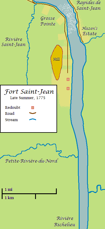 Fort Saint-Jean (click to enlarge). The Americans approached from the south (bottom of the map) via the Richelieu. This map was created by overlaying two early maps of the area on a modern map. The location of the roads and the course of the stream near Hazen's estate are quite approximate. Most difficult to determine was the areas of cleared land (shown on the map in yellow). The approximate dimensions of the cleared area around the redoubts is inferred from several sources. Much less is known about the cleared areas north of the fort; their representation here is speculative. There was likely also some cleared land near Petite-Rivière-du-Nord (at least there was a small house there), but this is not shown for lack of substantive information.
--------------
One of the better descriptions of Fort Saint-Jean appears in the journal of American Major Henry Livingston of the 3rd New York Regiment. He wrote the following (edited to bring the text in line with modern standards for capitalization and punctuation) in an entry dated November 21, 1775:
"The fortress of St. Johns lies near 130 miles north from Ticonderoga on the brink of Lake Champlain and about a quarter of a mile from the first rapid. [Note: Livingston evidently believed that the fort was on an arm of Lake Champlain]. It consists of 2 forts or redoubts near 100 yards asunder. The southern one rather the largest. In this is a brick house containing 2 clever rooms and Lintels back of them-- and a small potash house near it.
"In the north redoubt is a very large white stone house 2 stories high but unfinished within... The forts are about 100 feet wide each way in the inside; and mounted between them, upwards of 30 iron cannon besides brass field pieces (6 pounders) and several mortars.
"The wall is composed altogether of earth, and neatly sodded without, looking as green as the field around it.
"The whole surrounded with a ditch of 7 feet deep and 8 or 9 feet wide--picketed on the interiour side with timbers projecting from under the wall and over the ditch, and a little elevated, with their points made very sharp.
"Between the 2 forts there was a line of pickets placed (or posts) 10 feet high and close together...
"A ditch was also dug deep enough for men to pass unseen thro from one fort to the other, and between the pickets and the lake. Both the pickets and ditch were constructed after we built our eastern battery [i.e., in October, 1775].
"In each redoubt the enemy kept a union [i.e., a flag] displayed.
"It's 2 or 300 yards from the forts to the nearest woods or bushes. In general it's 5 or 600 to the woods--a low plain wet, and covered with excellent grass surrounds the fortress. If there is any elevation of the earth at all, it is where the forts stand.
"The wilderness west of St. Johns is an impassable quagmire--low, wet and covered with timber and brush--and for 7 or 8 miles north [sic, northwest] of the fort we meet with but one sorry log tenement which stood in our grand camp.
"Opposite the forts on the east of the lake the soil is also very wet and low; a perfect howling swamp. There are a considerable number of large hemloc trees [that] grow on this side and plenty of the balm-of-Gilead firs. North east of St. Johns at the distance of about a mile stands a large elegant house belonging to one Captain Hasen [i.e., Moses Hazen] with a considerable quantity of cleared ground around it. The captain has a saw mill standing on the rapids which are just by his house. These rapids are not so great but what rafts of boards and timber can at any time go down them and so into the River St. Lawrence. Our people frequently sent battoes down with cannon in them--and empty ones can be drawn up against the current.
"The fall is perhaps 100 yards in length. The breadth of the lake here as at St. Johns [is] between 3 and 400 yards.
"On the west side of the lake, from St. Johns northward there are settlements all the way to Chamblee [Chambly]; a house or two being in sight of the fort."
No comments:
Post a Comment